9.4 Geospatial data#
The term geospatial data refers to data that has a geographic component. This means that the records in a geospatial dataset have implicit locational information such as an address, city, or a postal code. A geographic information system (GIS) is a system designed to capture, store, manipulate, analyse, manage, and present geospatial data.
GIS data comes from satellite imagery that can create data-rich images with extracted vector features and attribute data. They can be used in mapping applications to achieve a multi-layered result for many types of analysis. Satellite imagery has significant potential to provide more timely statistical outputs, reduce the frequency of surveys, reduce respondent burden and other costs, and provide data at a more disaggregated level for informed decision-making.
The value of linking statistical information to location has long been recognised and implemented by NSOs for many years. This began with the use of GIS by the Canadian statistical office in the 1980s and has evolved over time as improved infrastructure, tools and skills have facilitated more advanced geospatial analysis. Such data has the potential to reveal new insights and data relationships that would not have been possible by analysing data in isolation.
It is now readily accepted that integrating statistical and geospatial information can play a key role in providing the data for decision-making processes at local, sub-national, national, regional, and global levels.
In particular, this is vital for measuring and monitoring the targets and global indicator framework for the SDGs. It will also be a vital element for future censuses. Such integrated information will also allow for comparisons within and between countries in a more harmonised manner.
Before using geospatial data, an NSO will need to consider the strategic questions as to what value can it provide, what risks are involved, how to work together with mapping agencies, the ways to improve location coding of statistics and how best to harmonise methods between statisticians and mapping agencies.
9.4.1 UN-GGIM Frameworks#
“Geospatial data, methods, frameworks, tools, and platforms are urgently needed, and reliable, timely, accessible and disaggregated geospatial information must be brought to bear to measure progress, inform decision-making and ensure effective and inclusive national and subnational programs that will chart the path towards the ‘Geospatial Way to a Better World’, to assist in the implementation of the sustainable development goals (SDG’s), and transform our world for the better.” The UN Secretary General’s opening statement at the first United Nations World Geospatial Information Congress, held in Deqing, China, in November 2018.
The 2030 Agenda for Sustainable Development is an overarching global framework, and oversight for all other frameworks and recognizes the critical importance of geospatial and Earth Observation. Over the past six years, the United Nations Committee of Experts on Global Geospatial Information Management (UN-GGIM) has developed several global geospatial frameworks supporting sustainable development and the integration of statistics and geospatial information. The overarching geospatial framework is the Integrated Geospatial Information Framework the (IGIF) and at the strategic level there are frameworks on disasters, statistical and geospatial integration, and land administration. At the bottom tier, there are frameworks on: Fundamental Geospatial Data Themes, the Global Geodetic Reference Frame, Standards Guides, Licensing of Geospatial Information, and Shared Guiding Principles.
The 2030 Agenda for Sustainable Development is an overarching global framework, and oversight for all other frameworks and recognizes the critical importance of geospatial and Earth Observation. Over the past six years, the United Nations Committee of Experts on Global Geospatial Information Management (UN-GGIM) has developed several global geospatial frameworks supporting sustainable development and the integration of statistics and geospatial information. The overarching geospatial framework is the Integrated Geospatial Information Framework the (IGIF) and at the strategic level there are frameworks on disasters, statistical and geospatial integration, and land administration. At the bottom tier, there are frameworks on: Fundamental Geospatial Data Themes, the Global Geodetic Reference Frame, Standards Guides, Licensing of Geospatial Information, and Shared Guiding Principles.
The connection between global development frameworks and UN-GGIM frameworks is the SDG’s Geospatial Roadmap (🔗), (to be presented for adoption at the 53 Session of the Statistical Commission). The SDGs Geospatial Roadmap is intended to help to “build the bridge” and to promote understanding between the statistical and geospatial actors working with the global indicator framework. It provides simple and actionable guidance for national statistical offices, national geospatial information agencies, custodian agencies and others working within the national Sustainable Development Goal ecosystem. It serves to convey how the Integrated Geospatial Information Framework (IGIF), the Global Statistical Geospatial Framework (GSGF), and other frameworks have an important “integrating” role in advancing the 2030 Agenda.
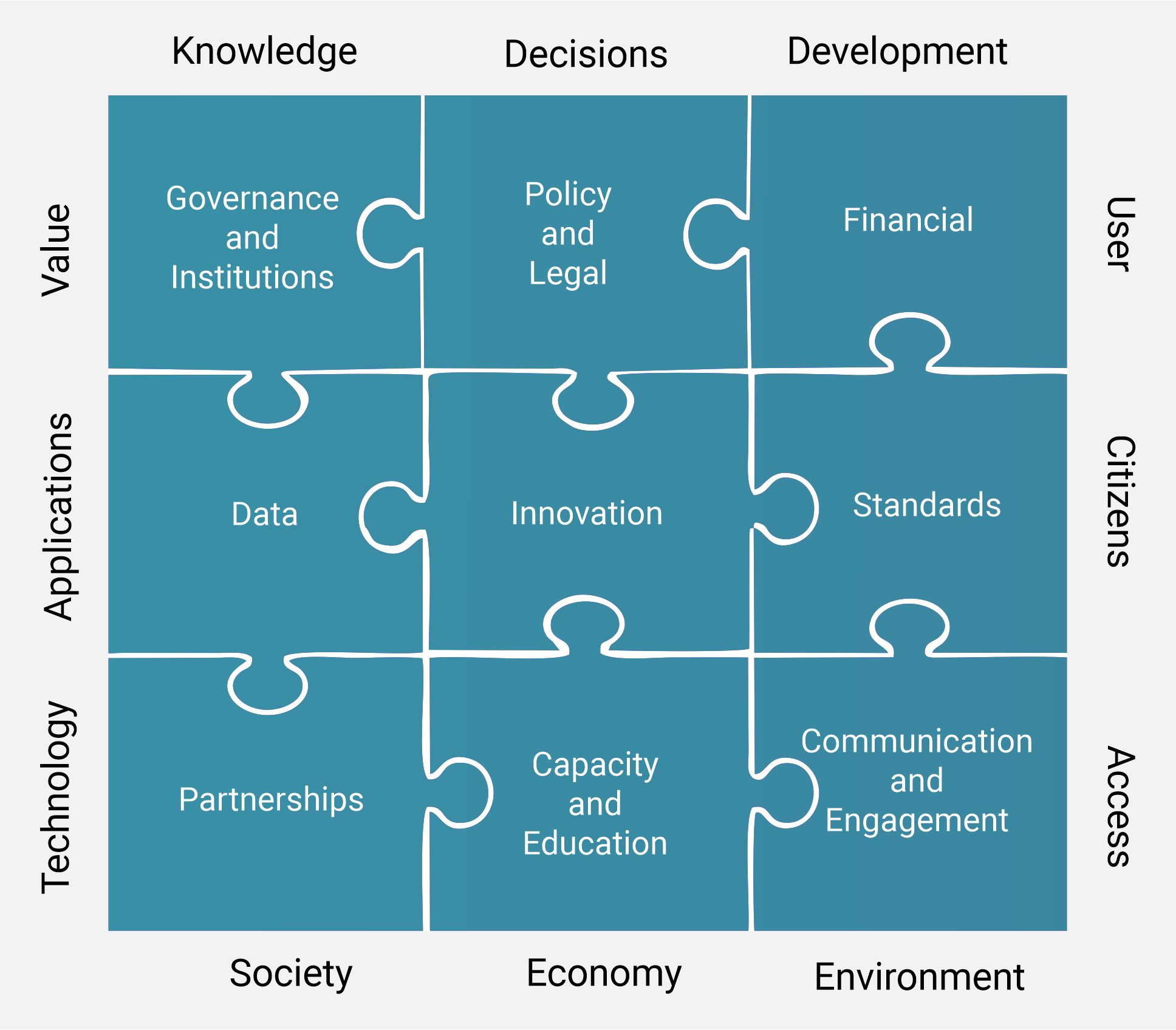
The Integrated Geospatial Information Framework (IGIF) (🔗) the umbrella geospatial framework provides the specific guidance and recommended actions to be taken by Member States to establish, improve or strengthen their national arrangements in geospatial information management, systems and infrastructures, in particular in developing countries.
The IGIF acts as a catalyst for economic growth and stimulates improved decision-making for national development priorities and the Sustainable Development Goals (SDGs). It has three parts – an overarching strategy, nine implementation guides and country level action plans.
The Global Statistical Geospatial Framework (GSGF) facilitates the integration of statistical and geospatial information.
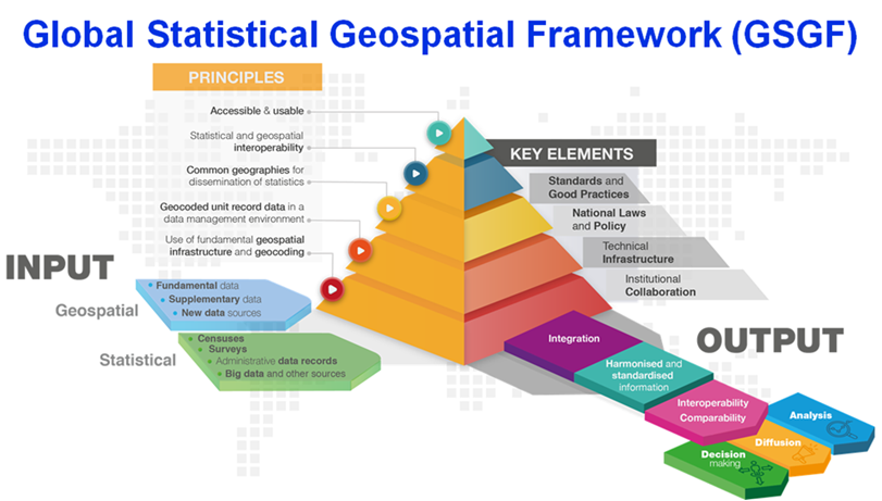
A Framework for the world, the GSGF enables a range of data to be integrated from both statistical and geospatial communities and, through the application of its five principles and supporting key elements, permits the production of harmonized and standardized geospatially enabled statistical data. The resulting data can then be integrated with statistical, geospatial, and other information to inform and facilitate data-driven and evidence-based decision making to support local, sub-national, national, regional, and global development priorities and agendas, such as the 2020 Round of Population and Housing Censuses and the 2030 Agenda for Sustainable Development.
For other frameworks visit https://ggim.un.org/UN-GGIM-publications/
9.4.2 Types of geospatial data#
There are two basic types or forms of geospatial data:

Vector
This form uses points, lines, and polygons to represent spatial features such as cities, roads, and streams. Vector models are useful for storing data with discrete boundaries, such as country borders, land parcels, and streets.

Raster
This form uses cells (computer often use dots or pixels) to represent spatial features. Cities are single cells, roads are linear sequences of cells, and streams are collections of adjacent cells. Raster models are useful for storing data that varies continuously, as in an aerial photograph, a satellite image, a surface of chemical concentrations, or an elevation surface.
Eurostat - Geospatial analysis at Eurostat (🔗) - a set of techniques and tools to study space-time relationships inherent in data using examples where spatial analysis has been conducted with statistical data of the European Union (EU).
FAO - Guidelines on the use of remote sensing products (🔗) to improve agricultural crop production forecast statistics in sub-Saharan African countries.
UNSD - Crop Density mapping Land cover and land use statistics Spatial and Statistical Analysis (🔗) of Historic Climate Data Urban-Rural Systems population density distribution map.
9.4.3 Challenges for NSOs in using geospatial data#
As for many areas of technology, the main challenge for NSOs in the use of geospatial data is to recruit and retain staff with the necessary skills.
There is a high demand for GIS specialists and NSOs are often not able to compete with other public bodies and the private sector in the employment market.
An additional challenge is the cooperation with mapping authorities, which lead to the formation of the United Nations Global Geospatial Information Management (UN-GGIM). UN-GGIM aims to ensure that the national mapping and cadastral authorities work jointly with NSOs to contribute to a more effective management and availability of geospatial information, and its integration with other information, based on user needs and requirements.
GIS specialists (also referred to as GIS Analyst, GIS Technician, and Cartographers) are needed to build and maintain GIS databases and to use GIS software to analyse the spatial and non-spatial information they contain. They also analyse GIS data to identify spatial relationships, perform geospatial modelling or spatial analysis, and create thematic maps.
The ideal for an NSO is to have a specialised in-house Cartography or GIS unit, but this is beyond the means of many NSOs, especially in developing countries. However, there are many open-source desktop GIS software products available as well as free GIS data sources.
To enable interoperability of data sources, survey data should where possible be geo-referenced and linked to geospatial data.
Examples of GIS open-source software:
GRASS GIS (🔗) – software suite used for geospatial data management and analysis, image processing, graphics and maps production, spatial modelling, and visualisation.

ILWIS (Integrated Land and Water Information System) (🔗) is a geographic information system and remote sensing software for both vector and raster processing. Its features include digitising, editing, analysis and display of data, and production of maps.

OpenJUMP (🔗) is an open-source GIS that can read and write map files. It can also read from spatial databases and can be used as a GIS data viewer.
MapWindow (🔗) is a set of programmable mapping components for analysis and modelling.
QGIS (🔗) is a cross-platform desktop geographic information system application that supports viewing, editing, and analysis of geospatial data.

SAGA (🔗) is a geographic information system used to edit spatial data.
GIS Data Sources:

Esri Open Data (🔗) provides access to more than 67k open data sets from organizations worldwide. Data can be searched by topic or location and download in multiple GIS formats.

NASA Earth Observations (NEO) can browse and download imagery of satellite data from NASA’s constellation of Earth Observing System satellites.

NASA Socioeconomic Data and Applications Center (SEDAC). SEDAC is the Data Center of NASA’s Earth Observing System Data and Information System (EOSDIS) and provides libraries of downloadable maps and data.

Natural Earth (🔗) is a public domain map dataset featuring integrated vector and raster data and the means to create maps with cartography or GIS software.

OpenStreetMap (🔗) collects geodata and makes it available free of charge. It is a community of mappers who edit the geography as OpenStreetMap daily.

Open Topography (🔗) provides a portal to high spatial resolution topographic data and tools. Open Topography facilitates access to high-resolution, earth science-oriented, topography data, and related tools and resources.

Sentinel Satellite Data (🔗). The European Space Agency’s Sentinel satellite high-resolution spatial data is available to the public for free. The Copernicus Open Access Hub provides complete, free and open access to user products.

Terra Populus (TerraPop) (🔗) incorporates and integrates both census data from over 160 countries around the world, as well as environmental data describing land cover, land use, and climate.

UNEP Environmental Data Explorer (🔗) is the source for UNEP’s data sets and its partners in the Global Environment Outlook (GEO) report and other integrated environment assessments. Its online database holds more than 500 different variables, such as national, sub-regional, regional and global statistics or geospatial data sets (maps), covering themes like Freshwater, Population, Forests, Emissions, Climate, Disasters, Health and GDP.

USGS Earth Explorer (🔗) is a source of Geographic Information Systems (GIS) Data. USGS collects, monitors, analyses, and provides science about natural resource conditions, issues, and problems.
Central Statistical Bureau of Latvia thematic maps (🔗);
European Forum for Geography and Statistics (EFGS);
Eurostat - Merging statistics and geospatial information in the European statistical system (ESS);
Statistical and Spatial Frameworks. Standards and Data Infrastructure, Working paper, Statistics Australia (🔗);
National Institute of Statistics of Rwanda Geodata Portal (🔗);
Statistics Korea - GIS, Maps and Statistics (🔗);
Statistics Poland: Statistical Atlas of Poland (🔗);
Statistics Sweden - Implementing a Statistical Geospatial Framework (🔗);
United Nations Expert Group on the Integration of Statistical and Geospatial Information - Global Statistical Geospatial Framework Linking Statistics and Place (🔗);
UN Task Team on Satellite Imagery and Geo-Spatial Data (🔗) provide strategic vision, direction and development of a global work plan on utilising satellite imagery and geospatial data for official statistics and indicators for post-2015 development goals;
UNICEF Guidelines on the use of geospatial technologies (🔗).